The larger frame
The larger frame: FDOT, the corridor and the platform family
Orlando Sanford International sits inside a state agency, a corridor and a family of twins. This page shows each, with its source.
A one-minute reading. Each statement carries a source number that opens the list at the end, with the label (Read, Snippet only, Not found) and the date checked. Test data: carefully crafted and curated test data for common use cases. Readings are marked as readings. Nothing here is a commitment, an approval or a price.
FDOT
The Florida Department of Transportation has a Central Office that sets policy and standards, seven districts each led by a district secretary, and a Turnpike Enterprise. [F1] Read
District Five covers nine counties: Brevard, Flagler, Lake, Marion, Orange, Osceola, Seminole, Sumter and Volusia. Seminole County is where the airport is. [F2] Read
What FDOT does for airports
- It licenses public airports and inspects before licensing and renewal. It may accept an FAA Part 139 inspection. [F6] Read
- It runs the Statewide Airfield Pavement Management Program: an inspection about every three years for 95 public-use airports, a report for each, and an interactive map of Pavement Condition Index data. [F5] Read
- It keeps the Florida Aviation System Plan. The latest was developed in 2018 with the FAA and the public airports. [F4] Read
- It funds airport projects. The next section's programme list shows how. [F3][F7]
What it means for Sanford
The twin uses FDOT's 2022 District Five pavement inspection of SFB: runway PCI 58 on 18/36, 63 on 9C/27C, 71 on 9L/27R and 68 on 9R/27L. FDOT inspects about every three years, so a newer inspection may exist, and its date is not confirmed. [F11] Read Not confirmed The repository's reading is that most terminal deferred maintenance at SFB is 50/50 state money. [F12] A reading
Where to see it on this site Pavement and runway screens in the proof of conceptThe source registerThe Exploder
The corridor
The airport's address is 1200 Red Cleveland Blvd, Sanford, Florida 32773. [A1] Read
Near the airport, OpenStreetMap shows I-4, SR 46 (25th Street), East Lake Mary Boulevard and Airport Boulevard. It also shows the SunRail stations DeBary, Sanford, Lake Mary and Longwood. [C1] Read
- SunRail's Sanford Station is at 2720 W. State Road 46, at SR 46 and Airport Boulevard, with a park and ride lot and a bus drop-off area. [C2] Read
- LYNX lists routes 34, 46E, 46W and NeighborLink 851 as SunRail connections at Sanford. [C3] Snippet only
- SR 417, the Seminole Expressway, is operated by Florida's Turnpike Enterprise from Aloma Avenue at the Seminole County line north to I-4 in Sanford. [C5] Read
- The SR 452 Seminole Connector is a Central Florida Expressway Authority project, not an FDOT District Five project. It runs from SR 417 to Red Cleveland Blvd at the airport entrance, 2.3 miles in the work plan. The alignment was chosen on 2025-10-09, design runs late 2026 to early 2030, construction is 2031, and completion is to be set. Re-check before use. [C6] Read
- MetroPlan Orlando is the planning organisation for Orange, Osceola and Seminole counties. It lists a 2050 Metropolitan Transportation Plan and a Transportation Improvement Program. [C7] Read
- A rail link from SunRail to the airport: no current plan was found in the search of 16 November 2026. [C4] Not confirmed
- That SFB is among the Strategic Intermodal System's Strategic Growth airports on FDOT's own map is to be confirmed. [C8] Not confirmed
The diagram is a schematic of who serves the airport, as the sources name them. It is not a map and not to scale. The dashed box is planned and not built.
What it means for Sanford
The airport's access is split between owners: FDOT District Five, the Turnpike Enterprise, CFX, SunRail and the city and county. A twin that holds the airport side can show the same record to each of them. A reading
Where to see it on this site The InterchangeThe ExploderGround transportation screensThe growth flight
The family of twins, with Municipath
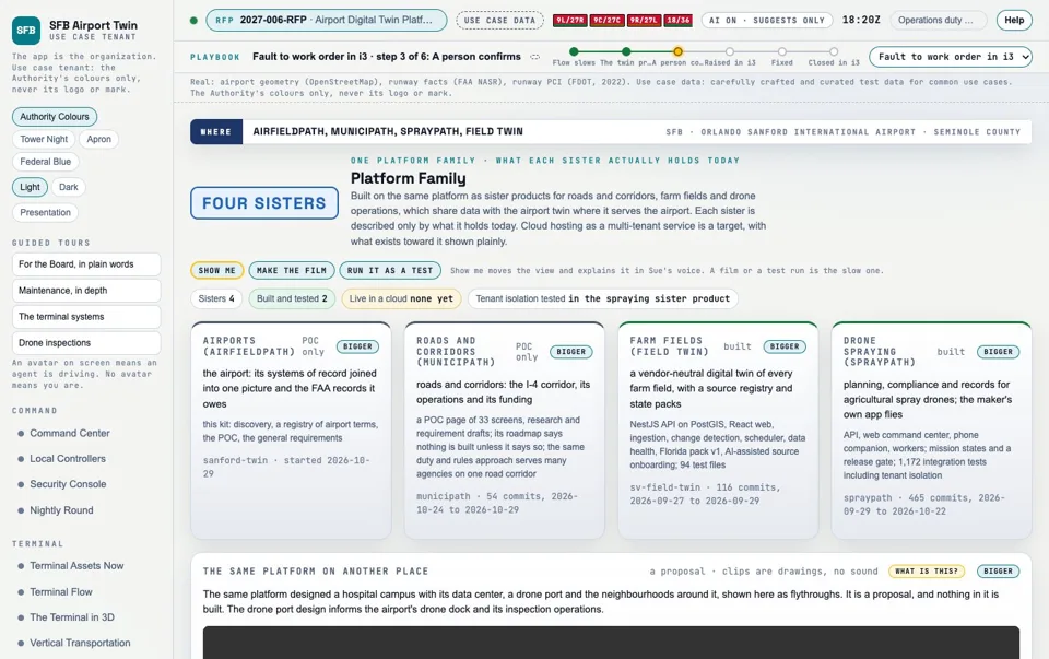
Airfieldpath has sister products. The platform family screen lists each by what it holds, built or proof of concept only. [M5] Read
Field Twin
A built API, web app and ingestion with 94 test files, Florida pack v1, run locally in Docker. [M5]
Built
SprayPath
A built API, web command center and phone companion; 1,172 integration tests per its commission report of 2026-10-05. [M5]
Built
Airfieldpath
This site and its working kit: a proof of concept on carefully crafted and curated test data for common use cases. [M5]
Proof of concept
Municipath
Roads and corridors, the I-4 corridor. A proof of concept page of 33 screens, with research and requirement drafts. Its roadmap says nothing is built unless it says so. [M1]
Proof of concept
No sister product is live in the Airfieldpath proof of concept.
Municipath
Municipath is the sister product for roads and corridors. Its proof of concept screens include The Interchange, Corridor Now, Incident, Evacuation and Events, Drone Stations, Hot Spots, Corridor Study, Intake, Funding Radar, Application Builder, Grant Pipeline, Project Artifacts, Accountability and State Packs. [M2] Read Proof of concept
It is designed to manage FDOT projects, grants and twins. The project's own description is that grants are the spine: every screen shows how it serves funding success, every claim in a grant package is backed by a record with its source and date, and each state is a tagged, versioned pack. It integrates with FDOT's SunGuide traffic management software rather than replacing it, and it may only slow traffic and never steers a vehicle. [M3] Read Design, not built
Its research states that the proof of concept is to be grounded in the real current projects, issues and grants of the Orlando I-4 corridor. [M8] Read
The Inflector, a road marker that senses, is a design and is not built. Light beyond today's rules needs an FHWA experiment requested by FDOT. [M4] Read
How the Authority could benefit from the family
- The roads and corridors around the airport, read in the same record as the airport. A reading
- FDOT project and grant tracking from the same pipeline the Authority's own grant screens use. [M6] A reading
- Twins that share the Interchange and asset tags. Interchange is ours; Jira feeds it; no real Jira and no real i3 has been called, but we will be ready. [I1] A reading
The RFP grows the same way: the Authority "envisions the Digital Twin Platform as a long-term enterprise capability that will serve as the foundation of an Airport Digital Twin 'Ecosystem'". [R1] Read
Where to see it on this site MunicipathThe platformThe platform family screen
The four-step process, repeated
The process is the same each time. Find a pool of funding. Match a need to it. Present the match and turn it into a plan. Then repeat it for the next jurisdiction and the next pool. A reading
1. Funding search
A pool is found and read from public pages. These are the programmes read for this page, with what each page says. Amounts appear only where a page states them.
| Programme | What it says | Who | Source |
|---|---|---|---|
| FDOT Aviation Grant Program | Financial assistance to Florida airports for safety, security and preservation, paid from the State Transportation Trust Fund. | Florida public airports | [F3] |
| Public Transportation Grant Agreement | FDOT's main contract for funding aviation projects. FDOT may fund up to 50 percent of the nonfederal share of eligible costs (Fla. Stat. 332.007(6)(a)). Airports keep their capital list in the JACIP. | Airports with a project on the JACIP | [F7] |
| Five-Year Work Program | FDOT's online list of funded projects, built under Fla. Stat. 339.135. The SIS First Five Year Plan lists the Strategic Intermodal System projects the Legislature has funded in it. | Read it to see what is funded and when | [F8][F9] |
| Transportation Regional Incentive Program (TRIP) | Encourages regional planning and invests in regionally significant roads and transit. The State-Funded Infrastructure Bank is a loan programme and cannot give grants. | Regional partners (see the FDOT page) | [F3] |
| FAA Airport Improvement Program | Grants to public agencies, and in some cases private owners, for planning and development of public-use airports in the National Plan of Integrated Airport Systems (49 U.S.C. chapter 471). Operating costs such as salaries, equipment and supplies are not eligible. | Airports in the NPIAS | [P1][P5] |
| FAA Airport Infrastructure Grants | An Infrastructure Investment and Jobs Act programme for runways, taxiways, safety and sustainability projects, terminals, airport transit connections and roadways. The FAA reports the fifth and final installment for FY26. | Airports (see the FAA page) | [P2] |
| Passenger Facility Charge | A charge under 14 CFR Part 158 imposed by a public agency on passengers enplaned at a commercial service airport it controls. | The airport operator | [P3] |
Snippet only: F8, F9, P1. Read earlier: F7, P2 to P5.
2. Analysis
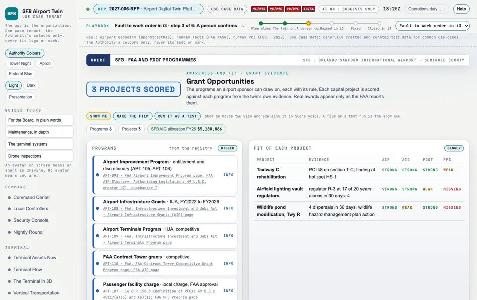
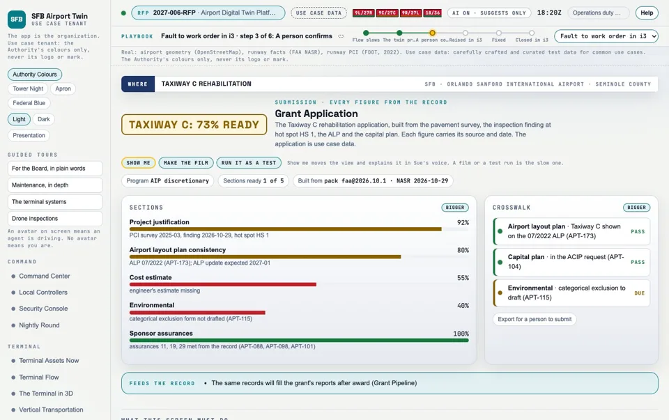
Analysis matches a jurisdiction's needs to a pool's criteria with traceability: a requirement row points to a screen, and a screen points to a component. For Sanford, the RFP is the worked analysis. The requirements matrix holds all 147 rows of RFP 2027-006 and its attachments. [T1] The Airfieldpath grant screens score a programme's fit from the twin's evidence: Grant Opportunities, Grant Application and Grant Pipeline. [M6] Proof of concept
A written method for finding who is likely to win a public opportunity, the sleuth, is the design for a feature of Municipath's funding radar. It profiles companies only and every fact carries a source and a date. [M7] Design, not built
3. Presentation
This site, its films, its sheets and its narration are the worked presentation for Sanford. The parts that repeat are the template: the page structure, the source register, the requirement-to-screen map and the film recipe. The parts that change are the data: the jurisdiction's records, its programmes and its photographs.
4. Opportunity
A funded need becomes an award, a phased plan and a rollout. For Sanford the worked example is the plan of 12 phases and 100 work units, with the horizons page. [T1] Read The Authority's Board agenda of 2026-10-06 lists approval of two grants, Digital Twin and Class 8 Municipal Trucks. [A2] Read
Repeating it
The same four steps fit airports, roads and corridors, counties, cities, and farm fields with drone spraying, which is the range the family of twins covers. [M5] A reading Few have solutions here: the market note recorded 21 airport digital twin deployments or programmes, 5 US solicitations, awards or funded programmes from 2024 to 2026, 12 platform vendors profiled and 0 confirmed Florida airport digital twin deployments. Not confirmed never means false. [K1] Read
What this means for the Authority. The Authority can use the same process for its own funding questions. A reading
Where to see it on this site The RFP and the planThe requirements matrixFilmsThe horizons page
The corridor and the Authority, working together on the platform
This is a reading of the three, five and ten year horizons. The Authority's own master plan has near, mid and long term bands of 0 to 5, 5 to 10 and 10 to 20 years. [K2] Read Everything below is A reading and is for discussion. None of it is approved or promised. Each item grows from a phrase in the RFP [R1] and names a funding pool from the process above.
3 years (near term, 0 to 5 years)
One funding calendar for the airport and the roads around it
Who works with whom: The Authority with FDOT District Five and MetroPlan Orlando.
Platform parts: Municipath funding radar and grant pipeline, the Airfieldpath grant screens.
Funding pool: FDOT Aviation Grant Program and Public Transportation Grant Agreements; the Five-Year Work Program.
From the RFP: "Ability to expand as airport needs evolve".
The Work Program read against the capital list
Who works with whom: The Authority and FDOT District Five.
Platform parts: The opportunity engine and the traceability from need to record.
Funding pool: The Five-Year Work Program; the JACIP capital project list.
From the RFP: "expand through future integrations".
The pavement record shared with the state inspection
Who works with whom: The Authority and FDOT.
Platform parts: The Exploder pavement layers and the FDOT pavement figures already on the site.
Funding pool: Aviation Grant Program (preservation).
From the RFP: "additional integrations, assets, facilities, dashboards".
5 years (mid term, 5 to 10 years)
A shared layer for the airport edge and its access roads
Who works with whom: The Authority, the City of Sanford and Seminole County.
Platform parts: The Exploder, shared asset tags, Municipath corridor screens.
Funding pool: TRIP for regionally significant roads; FAA Airport Infrastructure Grants name airport roadways and transit connections.
From the RFP: "foundation of an Airport Digital Twin Ecosystem".
A grant package built from records, for a joint project
Who works with whom: The Authority and a corridor partner named in the Work Program.
Platform parts: Municipath grant pipeline: every claim backed by a record with its source and date.
Funding pool: FAA Airport Improvement Program; state programs.
From the RFP: "Provide a future roadmap for logical expansion".
Work routed between owners through the Interchange
Who works with whom: The Authority and the owners of neighbouring assets.
Platform parts: The Interchange, shared asset tags.
Funding pool: Whatever the shared project qualifies for.
From the RFP: "through additional integrations".
10 years (long term, 10 to 20 years)
An annual report from one record
Who works with whom: The Authority, FDOT District Five and MetroPlan Orlando.
Platform parts: The twin record, the Municipath accountability screens.
Funding pool: The comprehensive airport infrastructure programme certified to FDOT each year.
From the RFP: "Ability to expand as airport needs evolve".
The surface connection studied with the data in hand
Who works with whom: The Authority, CFX, SunRail and LYNX.
Platform parts: The Exploder corridor layers, Municipath corridor study.
Funding pool: SIS and TRIP, as the programmes allow; a rail link to the airport has no current plan found.
From the RFP: "emerging technologies".
Visibility and recognition in municipal management
Who works with whom: The Authority and its partners.
Platform parts: The public record the work leaves: sources, dates, method.
Funding pool: None. This is an outcome of the method, not a funding source.
From the RFP: "a long-term enterprise capability".
A reading [R1]
The word notoriety here means visibility and recognition in municipal management, and it is an outcome of keeping sources and dates in the open. No claim is made about anyone else.
Where to see it on this site The horizons pageThe plan
Resources for the area
Every link below was loaded on 16 November 2026 and answered. Each links out to the owner's own page.
- FDOT District Five The nine counties District Five covers, including Seminole. Checked 2026-11-16.
- How FDOT is organised Central Office, seven districts and the Turnpike Enterprise. Checked 2026-11-16.
- FDOT Aviation The Office of Aviation front page. Checked 2026-11-16.
- Aviation funding information The Aviation Grant Program, the SIS, TRIP and the infrastructure bank. Checked 2026-11-16.
- Florida Aviation System Plan and planning process The 2018 plan and the regional committees. Checked 2026-11-16.
- FASP airport profiles One profile for each public airport, SFB included. Checked 2026-11-16.
- Statewide airfield pavement management The inspection programme and the Pavement Condition Index map. Checked 2026-11-16.
- Public-use airport licensing What an airport needs before aircraft use it. Checked 2026-11-16.
- Florida Aviation Project Handbook, 2025 How FDOT funds aviation projects (PDF). Checked 2026-11-16.
- Five-Year Work Program The online work program. Checked 2026-11-16.
- SIS First Five Year Plan Funded Strategic Intermodal System projects (PDF). Checked 2026-11-16.
- Regional transportation management centers FDOT's traffic management centres. Checked 2026-11-16.
- Airport Improvement Program The FAA programme page. Checked 2026-11-16.
- Airport Infrastructure Grants The infrastructure law programme for airports. Checked 2026-11-16.
- AIP handbook The rules for AIP grants. Checked 2026-11-16.
- Orlando Sanford International The airport's own site. Checked 2026-11-16.
- Taxis, shuttles and rides How passengers reach the airport by road. Checked 2026-11-16.
- MetroPlan Orlando The planning organisation for Orange, Osceola and Seminole counties. Checked 2026-11-16.
- SunRail The commuter rail line. Checked 2026-11-16.
- SunRail Sanford Station Address, park and ride and bus drop-off. Checked 2026-11-16.
- LYNX SunRail connections Bus routes that meet SunRail. Checked 2026-11-16.
- SR 452 Seminole Connector The Central Florida Expressway Authority project to the airport entrance. Checked 2026-11-16.
- Florida's Turnpike Enterprise Operator of the SR 417 section in Seminole County. Checked 2026-11-16.
- Seminole County The county government. Checked 2026-11-16.
- City of Sanford The city government. Checked 2026-11-16.
- Central Florida roads (CFLRoads) Live traffic information for the region. Checked 2026-11-16.
- USGS 3D Elevation Program The lidar terrain source the twin uses. Checked 2026-11-16.
- SFB airport diagram (FAA, public domain) The FAA airport diagram on Wikimedia Commons. Checked 2026-11-16.

Our own media
The airport digital twin, shown running, the growth flight, the opener, the Board cut and MissionSight are on this site. The Components catalogue holds the Exploder layers and screens: open it.
Sources
Read means the page or file was read in the part cited. Read earlier means it was read in a recorded earlier session and kept in the repository's registry or notes, and the link was checked to load on 16 November 2026. Snippet only means only a search summary was seen. Not found means it was searched for and not found. To confirm means a source points to it and it was not checked against the owner's page.
- F1 FDOT has a Central Office that sets policy and standards, seven districts each led by a district secretary, and a Turnpike Enterprise Read https://www.fdot.gov/agencyresources/organization.shtm, 2026-11-16
- F2 District Five covers nine counties: Brevard, Flagler, Lake, Marion, Orange, Osceola, Seminole, Sumter and Volusia; its secretary's address is in DeLand Read https://www.fdot.gov/info/moreDOT/districts/dist5.shtm, 2026-11-16
- F3 The Aviation Grant Program gives financial assistance to Florida's airports for safety, security and preservation, paid from the State Transportation Trust Fund; the Strategic Intermodal System is the network of facilities of statewide and interregional significance; the State-Funded Infrastructure Bank is a loan program that cannot give grants; TRIP encourages regional planning and invests in regionally significant roads and transit Read https://www.fdot.gov/aviation/fundinginfo.shtm, 2026-11-16
- F4 The latest Florida Aviation System Plan was developed in 2018 with the FAA and the public airports; the Continuing Florida Aviation System Planning Process has nine regional committees and one statewide committee Read https://www.fdot.gov/aviation/planning.shtm, 2026-11-16
- F5 The Statewide Airfield Pavement Management Program inspects pavement about every three years under s. 332.006, covers 95 public-use airports, writes a report for each, and hosts an interactive map of Pavement Condition Index data Read https://www.fdot.gov/aviation/pavement.shtm, 2026-11-16
- F6 A public airport needs an FDOT licence before aircraft fly to or from it, and FDOT inspects before licensing and renewal, and may accept an FAA Part 139 inspection Read https://www.fdot.gov/aviation/publicuseairport.shtm, 2026-11-16
- F7 A Public Transportation Grant Agreement is FDOT's main contract for funding aviation projects; FDOT may fund up to 50 percent of the nonfederal share of eligible costs under Fla. Stat. 332.007(6)(a); the JACIP is where airports keep the capital project list FDOT considers for funding Read earlier https://fdotwww.blob.core.windows.net/sitefinity/docs/default-source/aviation/2025-florida-aviation-project-handbook.pdf, 2026-10-29 (registry APT-196, APT-197, APT-199 in docs/domain-registry.json); link loads 2026-11-16
- F8 FDOT hosts the Five-Year Work Program online, built under Fla. Stat. 339.135 Snippet only https://fdotewp1.dot.state.fl.us/FMSupportApps/WorkProgram/WorkProgram.aspx, 2026-11-16 (search summary; link loads)
- F9 The SIS First Five Year Plan lists the SIS projects the Legislature has funded in the Work Program Snippet only https://www.fdot.gov/docs/default-source/content-docs/planning/systems/programs/mspi/pdf/Adopted_First_Five.pdf, 2026-11-16 (search summary; link loads)
- F11 FDOT's District 5 2022 pavement report inspected SFB: runway PCI 18/36 58, 9C/27C 63, 9L/27R 71, 9R/27L 68. FDOT inspects about every three years, so a newer SFB inspection may exist; its date is not confirmed Read earlier docs/research/sfb-facilities-2026-10-30.md rows F9 and F10, from the registry entry APT-201, 2026-10-30
- F12 Fla. Stat. 332.007(6)(a) lets FDOT fund up to 50 percent of the nonfederal share; the repo's reading is that most terminal deferred maintenance at SFB is 50/50 FDOT state money (inferred) Read earlier docs/research/sfb-facilities-2026-10-30.md row G5; docs/domain-registry.json APT-197, 2026-10-30
- A1 The airport's address is 1200 Red Cleveland Blvd, Sanford, Florida 32773; its site lists taxis, shuttles, rides, parking and rental cars Read https://flysfb.com/, 2026-11-16
- A2 The Authority's Board agenda of 2026-10-06 lists approval of two grants, Digital Twin and Class 8 Municipal Trucks (no amount in the record used here) Read earlier docs/domain-registry.json APT-216 (Sanford Airport Authority Board agenda 2026-10-06, item A), 2026-10-30
- R1 RFP phrases: the Authority "envisions the Digital Twin Platform as a long-term enterprise capability that will serve as the foundation of an Airport Digital Twin 'Ecosystem'" (Attachment C); "Ability to expand as airport needs evolve"; "Provide a future roadmap for logical expansion through additional integrations" (the sentence continues with assets, facilities and dashboards) Read docs/rfp/2027-006-RFP/Airport_Digital_Twin_Platform_Implementation_and_Support_Services.txt (lines 363, 472, 1103); 2027-006-RFP_-_Attachment_C_-_Detailed_Scope_of_Work.txt (lines 29 to 32), 2026-11-16
- C1 Roads and rail as mapped in OpenStreetMap near the airport: I-4, SR 46 (25th Street), East Lake Mary Boulevard, Airport Boulevard; SunRail stations DeBary, Sanford, Lake Mary and Longwood; Sanford (Auto Train) Read poc/build/sfb-access.json (OpenStreetMap contributors, Overpass API, retrieved 2026-10-29, ODbL 1.0), 2026-11-16
- C2 SunRail's Sanford Station is at 2720 W. State Road 46, at the intersection of State Road 46 and Airport Boulevard, with a park and ride lot and a bus drop-off area Read earlier https://corporate.sunrail.com/train-stations/sanford-station/, 2026-10-29 (registry APT-187); search summary and link check 2026-11-16
- C3 LYNX lists routes 34, 46E, 46W and NeighborLink 851 as SunRail connections at Sanford Snippet only https://www.golynx.com/plan-trip/riding-lynx/sunrail-connections.stml, 2026-11-16
- C4 A rail link from SunRail to the airport: no current plan found in the search results of 16 Nov 2026 (a guide says one was studied in the mid to late 2010s, with no update in five years) Not found web search 'SunRail Sanford station Orlando Sanford International Airport connection', 2026-11-16, 2026-11-16
- C5 SR 417, the Seminole Expressway, is operated by Florida's Turnpike Enterprise from Aloma Avenue at the Seminole County line north to I-4 in Sanford (mile 38 to 55); the Orange County section is operated by the Central Florida Expressway Authority Read earlier docs/domain-registry.json APT-206 (CFX SR 417 page; Florida's Turnpike Enterprise press release 2024-05-31), 2026-10-29
- C6 The SR 452 Seminole Connector (earlier the SR 417 Sanford Airport Connector) is a Central Florida Expressway Authority project, not an FDOT District Five project: from SR 417 to Red Cleveland Blvd at the airport entrance, 2.3 miles in the work plan; alignment chosen 2025-10-09; design late 2026 to early 2030; construction 2031; completion TBD. Re-check before use Read earlier docs/research/sr417-connector-2026-10-30.md; https://www.cfxway.com/seminoleconnector/, 2026-10-30; link loads 2026-11-16
- C7 MetroPlan Orlando is the metropolitan planning organization for Orange, Osceola and Seminole counties; it lists a 2050 Metropolitan Transportation Plan and a Transportation Improvement Program Read https://metroplanorlando.gov/about-us/, 2026-11-16
- C8 The 2025 FDOT handbook's map places SFB among the Strategic Intermodal System's Strategic Growth airports: to confirm on FDOT's own map To confirm docs/discovery-echo.md section 17, 2026-10-29
- P1 The FAA Airport Improvement Program gives grants to public agencies, and in some cases private owners, for planning and development of public-use airports in the National Plan of Integrated Airport Systems, authorised by 49 U.S.C. chapter 471; operating costs such as salaries, equipment and supplies are not eligible Snippet only https://www.faa.gov/airports/aip/overview, 2026-11-16 (the registry entry APT-093 read the FAA page on 2026-10-29; the page fetch was refused on 16 Nov, the link loads)
- P2 Airport Infrastructure Grants: an Infrastructure Investment and Jobs Act program for airport investments such as runways, taxiways, safety and sustainability projects, terminals, airport transit connections and roadways; the FAA reports the fifth and final installment for FY26 Read earlier https://www.faa.gov/bil/airport-infrastructure, 2026-10-29 (registry APT-108); link loads 2026-11-16
- P3 A Passenger Facility Charge is a charge under 14 CFR Part 158 imposed by a public agency on passengers enplaned at a commercial service airport it controls Read earlier docs/domain-registry.json APT-107 (14 CFR 158.3; FAA PFC program page), 2026-10-29
- P4 Each Florida commercial service airport keeps a comprehensive airport infrastructure program and certifies it to FDOT each year from 1 November 2025 Read earlier docs/domain-registry.json APT-116 (Fla. Stat. 332.007), 2026-10-29
- P5 FAA Airport Improvement Program entitlement and discretionary funds follow 49 U.S.C. 47114 and 47115 Read earlier docs/domain-registry.json APT-105, APT-106, 2026-10-29
- M1 Municipath is listed as roads and corridors, the I-4 corridor, with state 'Proof of concept'; the repo holds a POC page of 33 screens, research and requirement drafts; its roadmap says nothing is built unless it says so Read municipath/docs/roadmap.md; sanford-twin poc/seed/illustrative.json (family card 'Roads and corridors (Municipath)', built: false); stellarview docs/company/src/products.json, 2026-11-16
- M2 Municipath's POC screens include The Interchange, Corridor Now, Incident, Evacuation and Events, Drone Stations, Hot Spots, Corridor Study, Intake, Funding Radar, Application Builder, Grant Pipeline, Project Artifacts, Accountability and State Packs Read municipath/poc/screens.json, 2026-11-16
- M3 Municipath's design principles: grants are the spine and every screen shows how it serves funding success; every claim in a grant package is backed by a record with its source and date; each state is a tagged, versioned pack; it integrates with FDOT's SunGuide traffic management software rather than replacing it; it may only slow traffic and never steers a vehicle Read municipath/docs/discovery-echo.md (drafted 2026-10-24, items to confirm marked there), 2026-11-16
- M4 Municipath's roadmap: the Inflector (a road marker that senses) is a design, not built; light beyond today's rules needs an FHWA experiment requested by FDOT Read municipath/docs/roadmap.md, 2026-11-16
- M5 The Platform Family screen shows the sister products by what each holds, built or proof of concept only (REQ-FUNC-115). Field Twin: a built API, web app and ingestion with 94 test files, Florida pack v1, run locally in Docker. SprayPath: a built API, web command center and phone companion; 1,172 integration tests per its commission report of 2026-10-05. Airfieldpath: this kit, a proof of concept. No sister is live in a cloud today Read docs/discovery-echo.md section 17; poc/index.html SCREENS (family); poc/seed/illustrative.json, 2026-11-16
- M6 Airfieldpath's own funding screens: Grant Opportunities (programs, the rule and share of each, fit scored from the twin's evidence), Grant Application (sections built from records), Grant Pipeline (drafting to closeout), all in the proof of concept with test data Read poc/index.html SCREENS (radar, builder, grants), 2026-11-16
- M7 A written method for finding who is likely to win a public opportunity, called the sleuth, is the design for a feature of Municipath's funding radar and grant pipeline; it profiles companies only and every fact carries a source URL and a date. It is a method document, not a built feature Read municipath/docs/sleuth-method.md, 2026-11-16
- M8 Municipath's research states the proof of concept is to be grounded in the real current projects, issues and grants of the Orlando I-4 corridor Read municipath/docs/discovery-echo.md (end of file), 2026-11-16
- K1 The market note recorded 21 airport digital twin deployments or programmes, 5 US solicitations, awards or funded programmes from 2024 to 2026, 12 platform vendors profiled and 0 confirmed Florida airport digital twin deployments; 'not confirmed' never means false Read docs/research/airport-twin-market-2026-10-30.md (counts table), 2026-11-16
- K2 The Authority's own master plan has near, mid and long term bands of 0 to 5, 5 to 10 and 10 to 20 years (capital improvement programme, Table 7-2) Read docs/research/master-plan-database-2026-11-07.md; deploy/narration/data/horizons.json, 2026-11-16
- T1 The site's own screens, films and plan: 12 phases and 100 work units to June 2027 and the horizons page are read at build time from the repository Read deploy/narration/data/horizons.json; staging/e3-sanford-implementation/stellarview-plan.json, 2026-11-16
- I1 Interchange is ours; Jira feeds it; no real Jira and no real i3 has been called, but we will be ready Read deploy/site/README.md decision on the Interchange; deploy/narration/scripts/tour.md, 2026-11-16
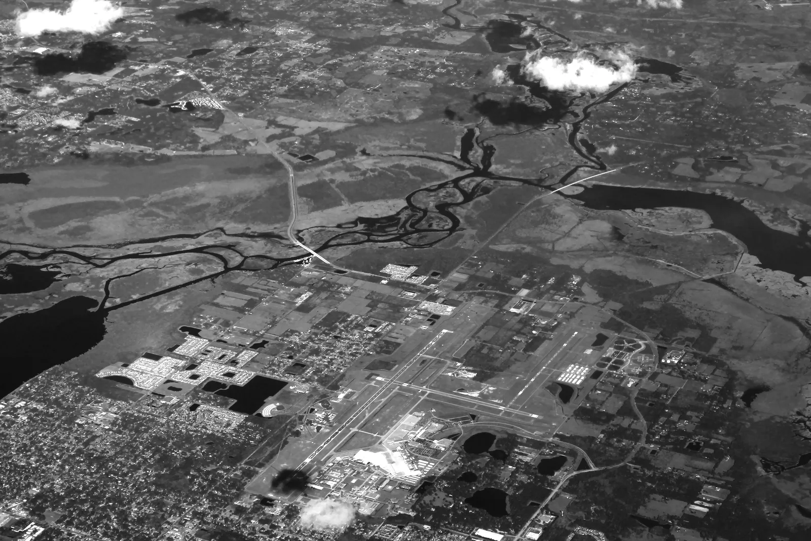
Image: "Aerial photo of Sanford Orlando Airport" by formulanone, CC BY-SA 2.0, via Wikimedia Commons (https://commons.wikimedia.org/wiki/File:Sanford_Orlando_Airport_Aerial.jpg). OpenStreetMap geometry is licensed ODbL 1.0, attribution OpenStreetMap contributors. [X1]